Words of wisdom

Words of wisdom

Saturday, October 10, 2015

10 DAYS ON THE ISLE OF MAN


Do you know where the Isle of Man is located?  Did you know that Douglas is the capital?  Did you know that the above photo is their national emblem?  Do you know what their world-famous TT is all about?  These were all questions I certainly didn't know the answers to when I accepted a 10-day house/pet sitting assignment there starting on September 24th.  

View of Douglas 
First - the Isle of Man is an island located half-way between Ireland and England (Dublin & Liverpool).  The island is 221 square miles of rugged coastline, castles, ancient standing stones, rural farmlands with big mountains in the middle. They have a very temperate climate year-round with warm summers and mild winters. But they get more rain per year than Ireland or Great Britain. The people of the island are called Manx and their language is from the Old Irish.   And of course, they drive on the wrong side of the road!  

The motto of their 3-legged symbol, which is on the Manx flag is "Whithersoever you throw it, it will stand."  In today's language, it would read,  ' Beware, if you shove us down, we'll get right back up!'  

The Isle of Man has had people living on it since 627 AD. It has been conquered by the Vikings, the Norse, the Scots and the English.  The Tynwald
Tynwald - The Manx House of Parliment
has been in existence since 979 AD, making it the oldest, continuously governing body in the world.  The United Kingdon is responsible for the island's defense and continuing good governance while the island's parliament and the government have complete control over all domestic matters.  The Isle of Man even has its own Manx money.

They also have an official 'fairy bridge' which I saw on my ride in from the airport.  I had learned while in Ireland that fairies are not the sweet, little Tinkerbell's Walt Disney wanted us to believe they were.  They are mischievous and sometimes down-right mean and are known from playing practical jokes.  So whenever you cross over the Fairy Bridge (please note that this is an official bridge with the Manx crest on the sign) you must always say hello to the fairies, thank them for anything good in your life, and wish them a pleasant day.  Believe me, I am not making this up.  Every single time I crossed the bridge, either with a bus full of locals or in a car with a local, each and every one of them  said hello to the fairies and wished them well!   


I was house/pet sitting for a lovely woman by the name of Mary Alexandra.  Her bungalow was a short distance from downtown Douglas, I had the care of Milo and Crystal, 2 adorable Shih Tzus.  


Mary picked me up at the airport upon arrival.  I had asked her to make me an appointment with her dentist, which she had done, and then she asked if I needed anything else while she was gone.  I said that a good haircut was in order and that's when I found out that that had been her profession for the past 45 years! She very generously gave me a great cut the next day before she and her good friend Brenda flew off for  their cruise of the Mediterranean. 

Mary also had put me on her insurance for the time I was there which meant once again I had access to a car to drive on the wrong side of the road.   I drove the ladies to the airport and was thrilled to see that the roads on the Isle of Man were SO much wider and straighter than those in Ireland.  Though it was great to have the car if I needed it, it was really much easier, and less stressful, to hop the bus that stopped at the corner whenever I wanted to go downtown.

I know Mary won't mind when I tell you that she very generously took me to Tesco for a big  'food shop' before she left.  But what she forgot to mention, and what I learned from her fabulous neighbors, is that Mary is not a cook.  It's something she very rarely does and therefore, her kitchen was minus a few things that make regular cooking easy.  There were no sharp knives (paring, carving). There were few pots and pans and no large bowls or food storage containers (Tupperware) with lids or a pitcher.  There wasn't even a can opener.  Thank you to Sue, Geraldine and Maureen who were kind enough to lend me everything I needed during the week so I could cook!! 

Across the street from Mary lived the nicest man by the name of Peter Bull. Upon retirement, Peter took up his hobby of photography and became so good that he is now a professional, doing weddings and special events, has his photos published regularly in the newspaper and the best thing, as far as he's concerned, is he is an official photographer for the TT.  


When I told Peter that I too loved photography, he very generously offered his time and we spent 2 days touring all around the island - and he drove!  

The first day Peter took me all around the 37-mile TT course.  This is the time to tell you just what the TT is, but instead of me rewriting everything about this annual event that brings over 200,000 attendees to this island of normally a population of 80,000,  let me just say it is one of the most well-known and popular motorcycle road races in the world.  Here is a link to the history of the TT on the Isle of Man where you read all about it.    

Two of Peter's photos from the 2015 TT


As we drove around the course, which of course, are just regular roads any other time of year except for 2 weeks in June, Peter explained how the island was divided into 4 areas known as The North, South, East, and West.  The course runs through all but The South part of the island.  Peter detoured off the course whenever he thought I would like to see certain points of interest, villages or castles. There are monuments to Manx riders who perished on the course and funny little lighthouses dotting the coastline, flower-laden seaside gardens and glorious views from the highest point of the course.  

Peel Castle


Our second day we did The South portion of the island.  Again, more beautiful vistas, castles, chapel ruins, a beautifully preserved, historical farming community, stately homes, waterfront battements and weird, 4-horned sheep.

St. Michael's Chapel
Castle Rushen

Cregneash
Milntown


   The back end of a 4-horned Manx Loaghtan


My last day on the island,  Peter took me to The Braaid.  In a farmer's field they had discovered the complete ruins of a Vikings round and long house, and  that evening I took a tour of the completely restored Gaiety Theater, founded in the mid-1800's and today offering a location for major touring shows and local productions.


I had a wonderful time on the Isle of Man.  The weather was perfect for my entire stay and the people I met were so welcoming and generous of their time and their household goods!  Mary has asked me to return next June for 3 weeks while she explores Canada and I've said - YES!

But now I'm off to catch a ferry to Liverpool and a train to Godmanchester, Cambridgeshire, UK for my next house/pet sit!

Until next time....


Thursday, October 8, 2015

THE FACES OF IRELAND

What made my visit to Ireland so memorable was the wonderful people I met along the way.  From  a long-time internet sewing friend who met me in Belfast to her parents who took me to tea in Bushmills;  relatives, neighbors and friends of friends in Virginia; a creative quiller at a craft fair in Belfast to the wonderful members of the International Woman's Club of Dublin.   Everyone was so welcoming and made my time in their beautiful country one that I will remember forever.


Tuesday, October 6, 2015

IRELAND - PART 3 - The Wild Atlantic Way Cond.


Did I mention that almost everywhere you go, you're being watched?  These wooly guys are literally wherever you look - on a mountaintop or in a valley, usually with a splash of colored spray painted on them designating who they belong to. 

After a lovely sleep and another full Irish breakfast, tops on my bucket list was a stop at  Sliabh Liag (Sieve League), the highest marine cliffs in Ireland.  If not as rugged or as popular as their southern neighbors, the Cliffs of Moher, these were rumored to be more beautiful.

But along the way I wanted to stop at the Fr. McDyer's Folk Village, completely  reconstructed and furnished just as the homes and shops were in Glencomcille when they were built and occupied in the 18th, 19th and 20th centuries.  Fr. McDyer arrived in 1951 and totally changed the village, lobbying for electricity, organizing local industry and thus stemming the flow of immigration out of the village.  It was an eye-opening way to see what life in this little village was like so many years ago and how much it has changed in some ways and others, not at all.


This area is known for it's knitting mills and shirt making factories.  I made a stop at Rossan Knitwear where I could have purchased sweaters for every member of my family but didn't.  But if Fisherman Out of Ireland had been open, I would have bought everything they had!  What wonderful knitwear this local company designs and sells.

Now it was time to drive to the top of the cliffs.  I was told not to use the car park at the bottom but open the cattle gate and drive up to the very top (2000+ feet) and I would find another car park there.  Let me tell you how much a 4-cylinder Kia does not like going straight up - and neither does its driver!  Again, an extremely narrow, one-lane road going up and up and up, all the way to the top of the cliffs.  I started in 2nd gear but had to shift down and did the majority of the drive up in 1st, gripping the steering wheel so hard I had to pry my fingers off when I finally reached the top.


I stepped out of the car and was greeted with the above view. The morning fog was hugging the very tops of the cliffs, but the sun was shining brightly and it soon disappeared and welcomed a gloriously clear day.


I chose these two photos specifically to show you that OSHA hasn't been heard of in Ireland - or Europe for that matter.  You can easily put yourself in my shoes and imagine where I am standing to take these photos.  Do you see any fences or guard rails protecting the observer from falling off the cliffs?  In the States, we wouldn't be able to get within 20 ft of the edge but I wasn't even 20 inches. European countries believe you should be smart enough to make decisions about your personal safety and it you do fall off the edge, then stupid you, it isn't their responsibility.  

Sieve League (Sliabh Liag) was absolutely beautiful.  It was well worth the drive up and the almost-as-scary ride back down.  The weather gods cooperated and it was a perfectly beautiful day.  What else was amazing was the sea - it was completely flat - like a mirror reflecting the sky.  The normally 'wild' and angry Atlantic was taking a breather and enjoying the calm day as much as I, and the rest of the sightseers were.


After a drive through the town of Donegal and around the O'Donnell stronghold, I followed the WWW signs to Bundoran-on-the-Sea where I would spend my last night on the Wild Atlantic Way at Rockpool House Air BnB.  It was raining and cold but I had dinner at the great pub.  Everything is better with a delicious hamburger, chips, and a pint.

The next morning  I turned away from the west coast of Donegal and headed toward Dublin with my destination being the village of Virginia in County Caven.  I had been invited by a friend to stay at her ancestral home and be part of the celebration of her 70th birthday.  Along the road, I just happened to see a sign that said Castle and I did a quick u-turn and was thrilled to find not only the ruins of Tully Castle but had the entire place all to myself!

Click on the photo to enlarge and read the history of the castle

I would spend the next 6 days in a lovely, 18th century home, still a working farm, helping to chop, cook, clean and get ready for approximately 100 guests, and then assist in the clean-up afterward.  This was my way of 're-paying' for the owner's generous hospitality.


The party was a great success.  Plenty of food, plenty of whiskeys and strong tea, and plenty of music and song.  I didn't make it till when the last guest left at 3:30 a.m., but I did fall asleep with the sounds of a beautiful Irish tenor voice drifting upstairs and into my room.


My next-to-last-day my hostess' wonderful sister-in-law offered to take me to the Loughcrew Passage Tombs.  These Neolithic tombs were built about 3000 BC and have recently been partially excavated. Like Newgrange which is only a few miles to the south, these were the burial grounds of what would have been the nobles of the era. Even then, the tombs were laid out in the form of a cross. 


The next morning I drove from Virginia back north to Belfast to return my rental car.  Then I hopped a bus back south to Dublin Airport and my flight to the Isle of Man.  My 18 days in Ireland had come to an end - but oh, what a memorable adventure it had been!  And I met such wonderful people.  I will do a short follow-up blog post on just them!

Until next time...

Monday, October 5, 2015

IRELAND PART 2 - THE WILD ATLANTIC WAY


The sign above is the one I will now follow for the next few days.  I took lots of photos to show you the places that I visited, but below is the Irish Tourist Board's video of the Wild Atlantic Way.  Watching it will show you just why I was so excited to drive this glorious, weaving, winding, and very narrow coastal road.  I only had time to go from the start in north Donegal to Sligo Town, but I've promised myself that I will return and drive all the way to the end in Cork.  


I caught the ferry just outside Castlerock, Northern Ireland to Greencastle in Donegal in the Republic of Ireland.  I had been told the place to start my coastal tour was Malin Head, as far North as North goes in Ireland.   Here is a link to the map of the WAW that will give you an idea of my route.


This narrow road (a word I will use over and over when describing Irish roads) wandered through a few small villages before literally ending with a view of the Atlantic Ocean that has nothing between where I was standing and the Arctic Circle.  Desolate, barren except for some grasses, an old radio tower and waves crashing into Hell's Hole.  

After a short walk around (it was very cold and windy) I was back in the Kia driving south as the ferry across Lough Foyle was no longer running.  I had to drive back down to Londonderry, around the end of the Lough and back through Letterkenny (hot spot of tech companies) and a short side-trip through Glenveagh National Park.  I hoped out of the car to take a photo of the castle and right back in,  as the midges (Ireland's answer to mosquitoes) were out in full-force and noses and ears and eyes are their favorite places to invade!  


I was headed to Dunfanghy, which is nestled at the foot of mountains, on the edge of the Atlantic and the location of Ireland's best Blues and Jazz Festival.  I had booked one night at The Forest Lodge B&B which was just lovely.  I had a beautiful, big feather bed and a glorious view outside my window. For dinner, I had a delicious seafood chowder and homemade wheaten bread at Lizzie's Diner.  


Jean Scott, the Lodge's owner, informed me I had to have a full-Irish breakfast to start my day.  Traditionally, the most common ingredients of this breakfast are bacon rashers, the most delicious pork sausages, fried eggs, black pudding (not a favorite) and fried tomato.  Sauteed mushrooms were also included, as well as hash browns and a slice brown soda bread.  All of this is washed down with a steaming cup of strong breakfast tea.  I could barely move when I finally finished.  

All during breakfast, Jean and her daughter-in-law were convincing me that I really had to drive the narrow, single-lane road up to the top of Horn Head. They kept telling me that even though this road was REALLY narrow, it was a circle and was just one-way, unless tourist who can't read the map or road signs or a local, who doesn't care, decides to want to go the other way!  

I crossed my fingers, said a prayer, and said sure, I would give it a try.  The day was just beautiful and who wouldn't want to see a glorious view!


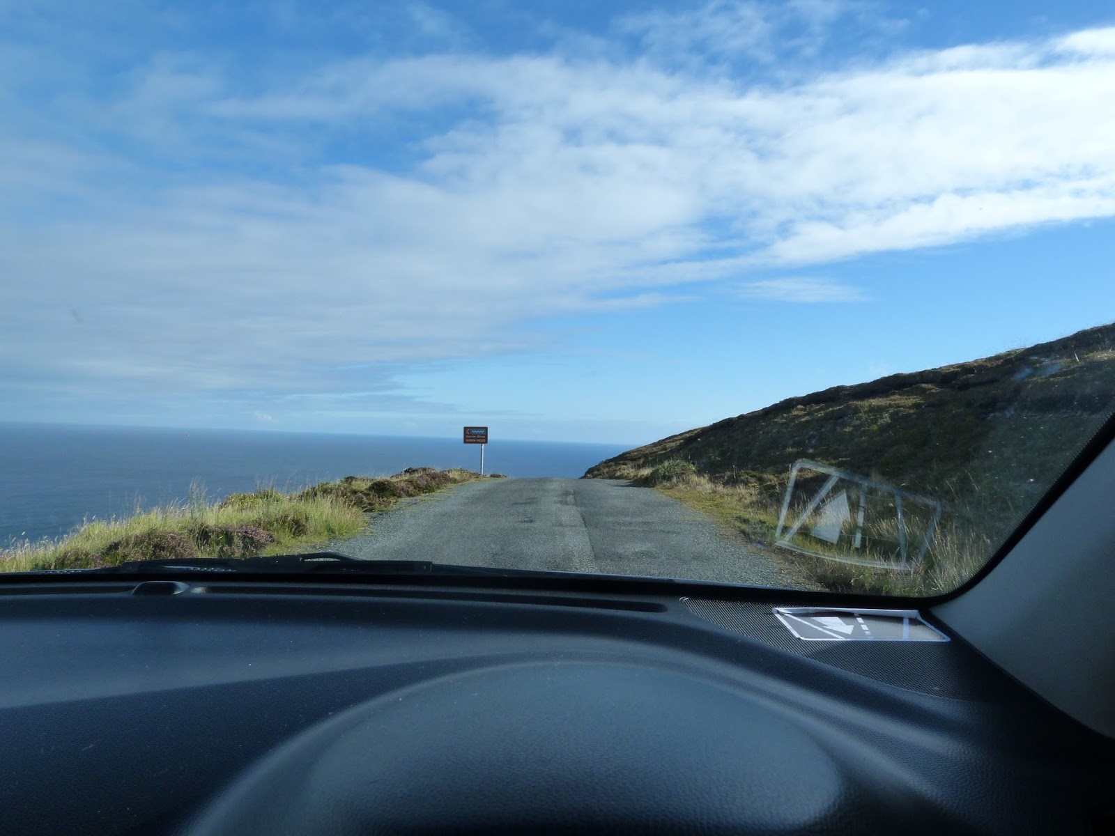
Maybe the above shot will give you an idea of the width of the road.  This was taken with me sitting behind the wheel of my tiny little Kia which is taking up the entire width of the road.  Please note:  There are NO shoulders and NO GUARDRAILS!  And yes,  it does looks like the road just ends and falls off the cliff into the sea.  (Also note the reflecting decal in the lower right-hand corner of the rental car window.  It's to remind we wrong-side-drivers where the car should be in relationship to the ---- line.  It helps!) 

I did meet a very nice gentleman who had just stopped and was standing in the middle of the road taking in the view.  We struck up a conversation since there was no option but to go around him and drive off the edge of the cliff.  This gentleman was a retired doctor from Northern Ireland who comes to this area of Donegal to hike the mountains.  He shared what he knew about the history of the area and told me all about his family.  It's just amazing the opportunities that arise when traveling to meet and talk to interesting people.

Driving south, following the sometimes confusing Wild Atlantic Way signs,  


the rest of the day I hugged the edge of the weaving, winding coastline of Donegal.  Being a strong, independent women who has no issues admitting when she is lost and asking for help, I meet some extremely nice people this day. You should know that Donegal is a Gaelic-speaking county.  All of the road signs are written in it, which makes an English-language map almost useless when trying to reach a destination what is spelled and pronounced completely differently than what you think it should be.  i.e. Sliabh Liag = Sieve League

The folks I asked for directions had very heavy accents but were more than happy to make sure I got to where I was headed.  But their first question was always  was 'Where are you from?'  Once I tell them, I learn that either they've been to the States (and they tell me where and when and why); or they tell me they have a relative living in Chicago and ask if I happen to know _______? (Fill in any good Irish name!).  

My destination for the end of this day was the village of Glencolumbkille.  What my lovely AirBnB hostess, Geraldine, didn't tell me, or maybe she wanted to keep it as a surprise, was that to reach the village I had to travel through the valley and over Glengesh Pass.  

This is one of the most beautiful places I have every seen - ever - which includes a drive up one of the most amazing and narrow roads I had yet to travel. The higher I got, the tighter the hairpin turns became.  I was literally turning back onto myself and I can't imagine what would have happened if I had met a car or truck coming from the other way.  There are no shoulders so no place to pull over and let another car pass.  When I reached the the top where there was a large car park where you can stop to breath and for photo ops.  Sitting there was a huge tour bus filled with Germans.  How he was going to manage those turns I didn't even want to think about - and I certainly didn't want to be in that bus!

Here are just two photos that don't even begin to show just how beatuiful this valley was.  Look close at the first photo and you can see the road winding up and up to the top of the pass.  


And here is the magnificent view from the top!


I'm going to leave you at the top for just a bit - as this Blogger program doesn't seem to like overly long blog posts.  Yesterday I lost 4 hours of work, so today I'm stopping after 2 today and will finish writing up the rest of my time in Ireland tomorrow.  

Until then.....